Find Nearby Accommodation
Hotels, apartments, hostels and luxury stays
We may earn a commission from bookings made through these links, at no extra cost to you.
About Abercrombie Caves
Abercrombie Caves sits on the traditional lands of the Burra Burra group of the Wiradjuri people.
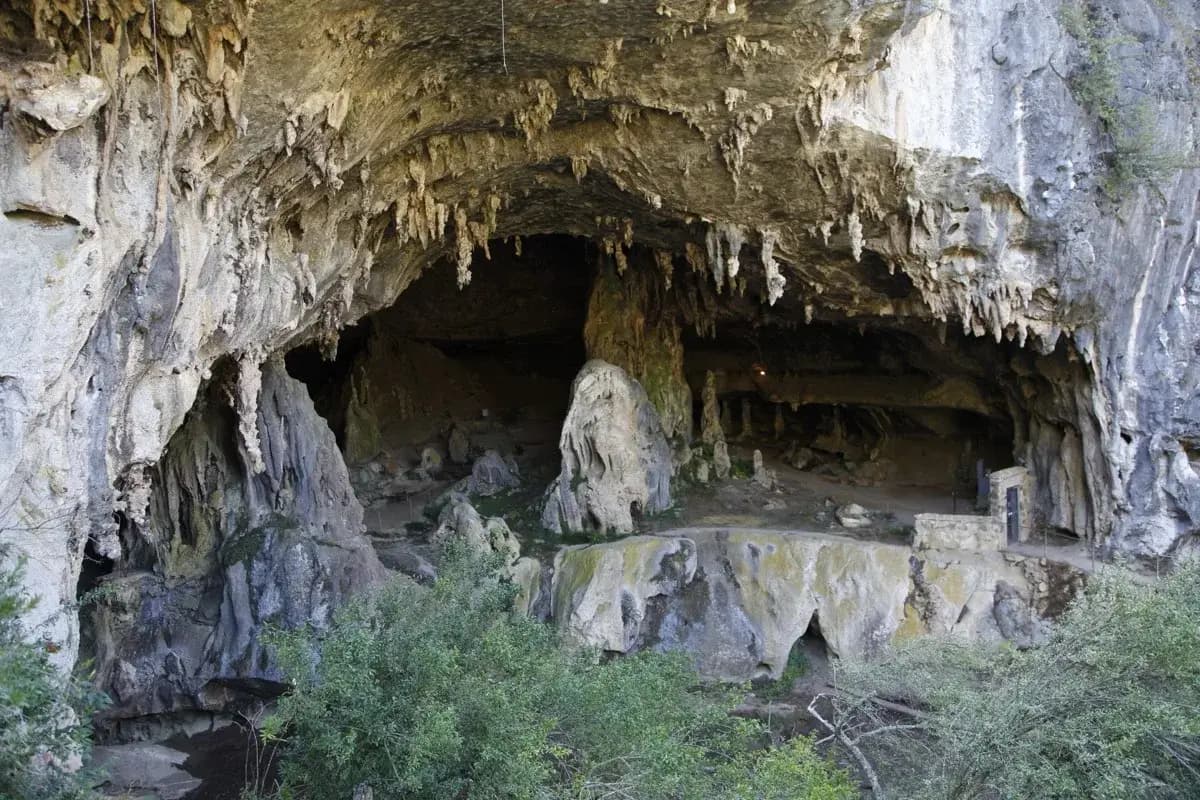
Limestone karst system featuring the largest natural arch in the southern hemisphere, with guided cave tours, bushwalking, swimming holes, and campground. Located 75 km south of Bathurst near [Trunkey Creek](/au/places/nsw/trunkey-creek).
**Temporarily Closed** — Abercrombie Karst Conservation Reserve is closed until mid-2026 while NSW National Parks repairs flood damage to the caves, walking tracks, campground, and accommodation. Contact the office on 02 6368 8603 (Thursday to Monday, 9am–4:30pm) for reopening updates.
Abercrombie Caves is a limestone karst system within the Abercrombie Karst Conservation Reserve, located 75 kilometres south of Bathurst in central New South Wales near the village of Trunkey Creek. The reserve covers 1,434 hectares and is managed by NSW National Parks and Wildlife Service. Its centrepiece is the Archway — claimed to be the largest natural limestone arch in the southern hemisphere, measuring 221 metres long, 60 metres wide at both ends, and 30 metres high in the middle.
History
The caves sit on the traditional country of the Burra Burra group of the Wiradjuri people. The original name for the area was Burrangylong Caverns — thought to be an Aboriginal word relating to the creek or wombats. In 1977, a research team found stone tools and extinct animal bones in a rock shelter north of the Great Arch, indicating thousands of years of Aboriginal presence in the area, though no artefacts have been found inside the Arch Cave itself.
European history at the caves is colourful. In 1830, the Ribbon Gang — a group of escaped convicts led by Ralph Entwistle during the Bathurst Rebellion — used the caves as a hideout. Several gang members were later tried and executed. The caves were officially documented by Surveyor W. R. Davidson in 1842, with Surveyor Wells discovering additional caves in 1843. Governor Charles Fitzroy and William Wentworth visited in 1844. Gold was discovered nearby in 1854, and the Mount Gray settlement above the caves became a mining community covering over 20 hectares. The area was declared the Abercrombie Karst Conservation Reserve in December 1997.
Cave Tours
Three tours operate at Abercrombie Caves:
Archway Cave (Self-Guided) — A 1.4 km walk through the Great Arch with 202 steps and automatic lighting. Allow about one hour. Suitable for all ages. Information signs and an accompanying leaflet cover the cave's geology and history.
Bushrangers Cave (Guided) — The main guided tour, running about 1.4 hours. Covers the history of the Ribbon Gang and their 1830 hideout. Scheduled Saturday and Sunday afternoons.
Grove Cave (Guided) — A more challenging guided tour through tight passages, high ceilings, and white cave walls featuring transparent shawls and straws. About 1.2 hours. Suitable for adults and children aged 7 and over. Includes an optional crawl section. Available by arrangement.
Walking and Swimming
Beyond the caves, the reserve has walking tracks worth exploring. The Grove Creek Falls walk leads to waterfalls with swimming holes — a good option in warmer months. The Mount Gray walking track reaches the historical 1880s gold-mining site above the caves. Both walks pass through bushland with birdwatching opportunities.
Camping and Accommodation
The campground has around 60 unmarked sites alongside the creek, suitable for tents, campervans, camper trailers, and small caravans. Facilities include hot showers, flush toilets, BBQ areas, a camp kitchen, drinking water, and a small kiosk. Check-in is 2pm, check-out 10am. Firewood must be brought in.
For those preferring a roof, Arch Cottage is a fully self-contained three-bedroom house sleeping up to six people, with an open fireplace. Two Grove Creek Cabins each sleep four adults, with ensuite facilities.
Getting There
From Bathurst (about 1 hour): drive south on Vale Road to Trunkey Road, turn left onto Goulburn Road at Trunkey Creek, then left onto Caves Road — approximately 13 km past the township. From Sydney, the drive takes around four hours via the M4 through the Blue Mountains. From Goulburn (about 120 km): head northwest through Crookwell, Binda, and Tuena, then turn right onto Caves Road about 16 km past the township.
The address is 272 Caves Road, Abercrombie River NSW 2795.
Visitor Tips
- Book cave tours in advance, particularly on weekends and school holidays
- Wear sturdy, closed-toe shoes with good grip — cave surfaces are uneven and can be slippery
- Bring a jumper or jacket regardless of the season — the caves maintain a constant temperature around 10-12°C
- The campground has a small kiosk selling snacks and drinks, but bring main meals if you are camping or visiting for the day
- Grove Creek Falls walk includes swimming — bring a towel and swimmers in warmer months
- Bring firewood if camping — it is required and not provided
- Visit on a weekday for smaller crowds, though note the reserve is closed Tuesdays and Wednesdays
Warnings
Getting There
Located 75 km south of Bathurst in central NSW, near the village of Trunkey Creek. From Bathurst: drive south on Vale Road to Trunkey Road, turn left onto Goulburn Road at Trunkey Creek, then left onto Caves Road (~13 km past the township). From Sydney: approximately 4 hours via the M4 through the Blue Mountains. From Goulburn (120 km): northwest through Crookwell, Binda, and Tuena, then right onto Caves Road (~16 km past the township).
Parking
Free parking available at the visitor area. Accessible parking near the entrance. Arrive early during peak times and school holidays.
Nearest airport
Visitor Tips
- •Book guided tours in advance, especially on weekends and school holidays
- •Wear sturdy closed-toe shoes with good grip for cave walks
- •Bring a jumper — caves stay cool year-round (around 10-12°C)
- •Allow 2-4 hours for a full visit including cave tour and walking tracks
- •The campground has hot showers, a kiosk, and BBQ facilities
- •Grove Creek Falls walk includes swimming — bring a towel in warmer months
- •Bring firewood if camping (required)
- •Check-in 2pm, check-out 10am for campground
Find Nearby Accommodation
Hotels, apartments, hostels and luxury stays
We may earn a commission from bookings made through these links, at no extra cost to you.
Quick Facts
At a Glance
Identity
- Traditional Name
- Burrangylong Caverns
- Traditional Owners
- Burra Burra group of the Wiradjuri people
The Place
- Area
- 14.34 km²
- Established
- 1997
- Significance
- Regional
Plan Your Visit
- Entry
- Adult $24 · Child $18 · Family $60
- Duration
- 2-4 hours (cave tour plus walking tracks and picnic)
- Best Time
- Any season works well since cave temperature is constant year-round. Spring (September-November) and autumn (March-May) offer pleasant weather for the surrounding bushwalks and swimming holes. Open Thursday to Monday; daily during NSW school holidays.
- Hours
- Thursday to Monday, 9am-4:30pm. Closed Tuesday and Wednesday. Open daily during NSW school holidays. Closed Christmas Day. NOTE: Currently closed until mid-2026 for flood repairs.
Location
- Region
- Central West
- State
- New South Wales
Good to Know
Highlights
Activities
Family & Visitor Info
- Ages
- All ages, but children under 5 may struggle with cave walking. Family-friendly guided tours available.
- Shade/Cover
- Limited shade
- Pram Friendly
- No
Food & Drink
Small kiosk at campground sells snacks and drinks. Picnic facilities available. Bring main meals if camping.
Features
Facilities
Travellers also visited
Tap + to build a trip
Find Nearby Accommodation
Hotels, apartments, hostels and luxury stays
We may earn a commission from bookings made through these links, at no extra cost to you.
Nearby
Campsites(5)
Trails(3)
Toilets(3)
Dump Points(3)
Tuena Campground Dump Point
Free · 12km
Lyndhurst Dump Point
Free · 39.6km
Lyndhurst Sports and Recreation Ground
Free · 39.7km