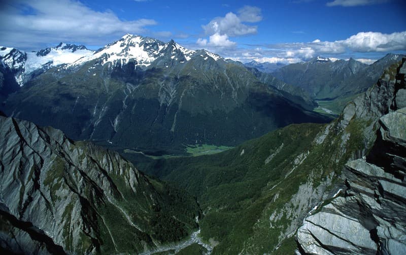
Mount Aspiring National Park
Tititea
Mount Aspiring National Park — National park in Wanaka, otago.
National Park in Otago
Photo: Wikimedia Commons (CC BY-SA)
 Written by Ben Cole· Updated Apr 2026
Find Nearby Accommodation
Hotels, apartments, hostels and luxury stays
We may earn a commission from bookings made through these links, at no extra cost to you.
About Mount Aspiring National Park
Named after Tititea/Mount Aspiring (3,033m), the highest peak outside the Aoraki/Mount Cook region. Part of Te Wahipounamu World Heritage Area, this vast alpine park spans from the Haast River to Queenstown. Features dramatic valleys, waterfalls, beech forest, and glaciers.
Mount Aspiring National Park covers 3,555 km² of Southern Alps wilderness in Otago, stretching from the Haast River south to Queenstown. It's the third-largest national park in New Zealand and forms part of Te Wahipounamu, the South West New Zealand World Heritage Area recognised for its outstanding natural and cultural values. At its heart stands Tititea — known in English as Mount Aspiring — rising to 3,033 metres, making it the highest peak in New Zealand outside the Aoraki/Mount Cook region.
The park encompasses a remarkable range of terrain: deep glacial valleys, braided rivers, ancient beech forests, cascading waterfalls, and active glaciers shaped over millennia by geological forces. Whether you're here for a gentle walk to a waterfall or a multi-day alpine expedition, the park offers experiences across a wide spectrum of ability and ambition.
What to See and Do
The park's most celebrated feature for walkers is the Routeburn Track, one of New Zealand's eleven Great Walks. The track traverses alpine terrain between Fiordland and Mount Aspiring National Park, passing through beech forest and above the treeline with views across wide mountain valleys. It's suitable for reasonably fit walkers aged eight and over, but it must be booked well in advance through the Department of Conservation — demand is high and hut spaces fill quickly, particularly in peak summer months.
For those wanting a substantial day walk without the multi-day commitment, the Rob Roy Glacier Track is a rewarding option. The 10-kilometre return walk follows the Rob Roy Stream through beech forest before opening up to views of the Rob Roy Glacier and surrounding peaks. It's accessible for children aged six and over with reasonable fitness.
The Blue Pools are among the more accessible highlights in the park. Located off State Highway 6 in the Haast Pass area, suspension bridges cross the Makarora River to viewing platforms above pools of remarkably clear blue water. The short walk suits visitors of all ages and fitness levels.
Thunder Creek Falls is another accessible stop along the Haast Pass highway — a short walk from the road leads to the base of a 28-metre waterfall dropping directly from alpine cliffs to the valley floor.
For those with the skills and experience, the park offers serious mountaineering terrain. Tititea/Mount Aspiring itself attracts experienced alpine climbers, and there are numerous technical routes throughout the park. Guided mountaineering and walking tours are available if you'd prefer to explore with local expertise.
Other activities within the park include jet boating, fishing, and photography. The dramatic scale of the landscape — glaciers, valley walls, forest-edged rivers — makes it a compelling subject at any time of year.
History
Mount Aspiring National Park was established in 1964 to protect this substantial stretch of Southern Alps wilderness. The park takes its English name from Tititea, the Māori name for the mountain, which translates loosely to "steep peak of glistening white." It sits within Te Wahipounamu, a World Heritage Area spanning the south-west of New Zealand's South Island, encompassing Fiordland, Westland, Aoraki/Mount Cook, and Mount Aspiring national parks. The area is recognised for both its outstanding natural landscapes and its deep cultural significance to Ngāi Tahu, the principal iwi of Te Wai Pounamu/South Island.
Getting There and Access
The main gateway towns are Wanaka and Queenstown. Wanaka sits roughly 50 minutes to 1 hour from the park's boundaries and is the closest major service town; Queenstown is 60 to 90 minutes away and offers a wider range of facilities and transport connections.
State Highway 6 runs along the western edge of the park through the Haast Pass, providing access to Thunder Creek Falls, the Blue Pools, and other roadside features. Most trailheads — including those for the Routeburn Track, Rob Roy Glacier, and Blue Pools — have free parking, though popular spots fill quickly during summer. The Routeburn trailhead in particular reaches capacity on peak days; arriving early is advisable.
There is no public transport to park trailheads. Car hire or organised tours are essential for most visitors. Shuttle services operate to the Routeburn Track and some other popular trails — these can be arranged through operators in Wanaka or Queenstown.
For accessibility information and current track conditions, the DOC visitor centres in both Wanaka and Queenstown are the best points of contact before you head in.
Visitor Tips
- Book the Routeburn Track early. Great Walk bookings open months in advance and popular dates sell out quickly. Book through the DOC website.
- Stock up before you arrive. There are no shops or food services inside the park. Resupply fully in Wanaka, Queenstown, or Arrowtown before you head in; picnic areas are available at some trailheads.
- Be prepared for rapid weather changes. Alpine conditions in this part of New Zealand can deteriorate quickly regardless of what the morning forecast shows. Quality waterproofs, warm layers, and a headtorch are recommended even for day walks.
- Check river conditions before crossing. River levels rise fast after rainfall and crossings that are straightforward in dry conditions can become dangerous or impassable. Check with DOC before departing.
- Start early. Long hikes in remote terrain leave little margin for delays. Getting an early start ensures you're not caught out by fading light or deteriorating weather.
- Shade is limited on many of the park's exposed alpine tracks. Sun protection is important, particularly on summer days.
Best Time to Visit
The park is open year-round, but November through March offers the most reliable conditions for walking and outdoor activities. This window corresponds to the New Zealand summer and early autumn, when snow has cleared from lower tracks and daylight hours are longer. The Routeburn Track's Great Walk season runs through this period. Winter brings significant snowfall to higher elevations, and some routes become inaccessible or require mountaineering equipment and experience.
Nearby Attractions
Wanaka is the most convenient base for the park and worth time in its own right — the town sits on the shore of Lake Wānaka and offers easy access to walking tracks, water activities, and a range of accommodation and dining options. Queenstown to the south is a larger hub with extensive visitor infrastructure. Travelling west on State Highway 6, the Haast Pass route connects to the West Coast and passes through some of the most dramatic scenery on the South Island. The Matukituki Valley, accessed from Wanaka, serves as the approach for many of the park's central trails including the Rob Roy Glacier walk.
Warnings
Getting There
Main access via Wanaka (90 minutes from park boundaries) or Queenstown (60–90 minutes). State Highway 6 follows the western edge. Shuttle services available for Routeburn Track and other popular trails. No public transport to trailheads; car hire or tour operators essential.
Parking
Free parking at most trailheads, including Routeburn, Rob Roy Glacier, and Blue Pools. Capacity varies; popular spots (Routeburn, Isenglass Creek) fill quickly in peak season. Some overflow parking available nearby. No official accessible parking data published; contact DOC visitor centres in Wanaka or Queenstown for accessibility details.
Visitor Tips
- •Book the Routeburn Track well in advance (popular Great Walk).
- •Start major hikes early to avoid darkness; alpine weather changes rapidly.
- •River crossings can be dangerous after rain — check conditions before departing.
- •Bring quality waterproofs, layers, and a headtorch even for day walks.
- •Stock up on supplies in Wanaka or Queenstown; no shops inside the park.
Find Nearby Accommodation
Hotels, apartments, hostels and luxury stays
We may earn a commission from bookings made through these links, at no extra cost to you.
Quick Facts
At a Glance
Identity
- Traditional Name
- Tititea
The Place
- Height
- 3033m
- Area
- 3562 km²
- Established
- 1964
- Significance
- National
Plan Your Visit
- Entry
- Free
- Duration
- 1-5 days
- Best Time
- November to March
Location
- Region
- Wanaka
- State
- Otago
Good to Know
Highlights
Activities
Family & Visitor Info
- Ages
- Varies by activity. Routeburn Track suits ages 8+ with good fitness. Rob Roy Glacier walk (16 km return) is accessible for ages 6+. Thunder Creek Falls and Blue Pools suit all ages. Alpine hikes and mountaineering require experience and fitness.
- Shade/Cover
- Limited shade
- Pram Friendly
- No
Food & Drink
BYO essential; no food services inside park. Picnic areas at trailheads. Resupply in Wanaka, Queenstown, or Arrowtown before entering.
Features
Facilities
Nearby
Campsites(5)
Trails(3)
Attractions(1)
Find Nearby Accommodation
Hotels, apartments, hostels and luxury stays
We may earn a commission from bookings made through these links, at no extra cost to you.